01/02/2024
Reshaping Disaster-Risk Policies: The Innovative Role of Tomorrow’s Cities in Computational ModellingSérgio Esperancinha with Chenbo Wang, Fabrizio Nocera and Gemma Cremen
Characterising the physical and social impacts of future natural hazard events.
The Hazard and Impact Modelling stage of the TCDSE involves assessing the effects of potential natural hazards—such as earthquakes and floods—on future urban scenarios using computational modelling.
It contributes to the design of more effective disaster risk reduction policies by addressing hazard impacts that extend beyond physical infrastructure and are directly relevant to the affected communities.
In the TCDSE, the impact assessment of a natural hazard event extends beyond assessing damage to infrastructure (buildings, water supply), and measuring impact in terms of financial losses, to encompass the intricate interconnections between the physical and social systems that underpin a city. For instance, data such as the number of casualties, injuries, displacements and loss of access to health and education for individuals from different socioeconomic groups and genders are calculated.
Modelling in Tomorrow’s Cities is also focused on future risk as defined by the communities themselves during the participatory approaches used in the previous components.
This novel strategy contrasts to current approaches to disaster risk modelling, which primarily concentrate on present-day risk, use metrics that are not people-centred, and predominantly emphasise economic impact over other dimensions of life.
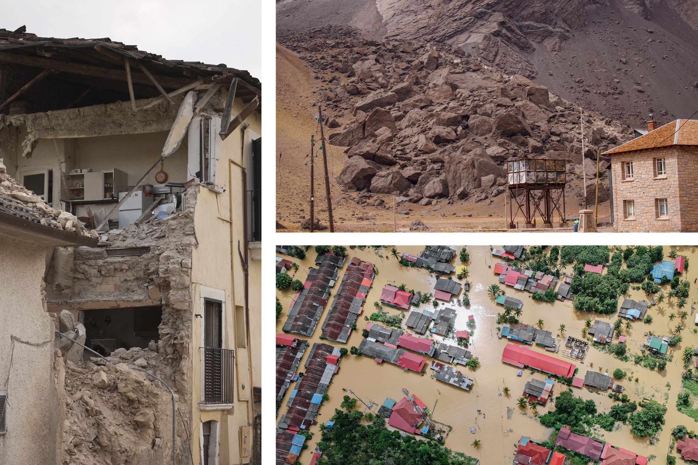
Toppled buildings as a consequence of an earthquake
This process involves three elements:
Multi-hazard Modelling begins with local teams identifying natural hazards that are relevant for a specific location by leveraging historical records, engaging stakeholders, conducting field surveys, and utilising other available sources. This inventory serves to create specific hazard scenarios for each identified hazard, which may entail the largest plausible event or a selected representative future event.
The Tomorrow’s Cities research team has devised efficient methodologies for selecting and adapting scenarios to account for future climate conditions. For instance, how the largest plausible flood event might escalate in magnitude based on current climate projections.
Following this, computational models are employed to simulate these events on the proposed Urban Scenarios (as outlined in the previous component). This enables the computation of hazard event characteristics/properties, which contribute to both physical and social impacts.
Equipped with this information, Impact Modelling can start.
The work involves using state-of-the-art engineering tools to assess the effects of hazards on the forthcoming physical infrastructure, such as buildings and transport infrastructure, to quantify the damage caused by hazards of varying intensities, in diverse urban settings, and with different building materials.
The analysis is complemented by socioeconomic and demographic projections, and by agent-based modelling, that account for the relationships between people and urban systems and infrastructures. Using the social data gathered during earlier stages of the TCDSE, which includes demographic and socioeconomic information on individuals, mobility trends, and the spatial distribution of social infrastructure dependency within the urban area, Tomorrow’s Cities Social Impact Module assesses and categorises the impacts of upcoming multi-hazard scenarios on different social groups that inhabit the city, particularly the most marginalised.
By integrating the damage to infrastructure and the social consequences of hazards, people-centred Impact Metrics are derived. Focused on the city-yet-to-be-built, these metrics, such as the number of displaced households, children facing education disruptions, or workers becoming unemployed, offer insights into the societal repercussions of hazards. Furthermore, these metrics can be broken down by age, gender, and income, providing valuable insights into how disasters disproportionately affect different social groups, including children, women, and marginalised future residents.
Utilizing a scenario-based approach to hazard characterization aids in making the impacts understandable to non-technical stakeholders, aligning with one of Tomorrow’s Cities’ core objectives: democratising risk assessment.
Impact survey deployment in Khokana, Kathmandu. Surveys such as these provide information on the most relevant impact metrics for the communities.
The flood damage assessment encompasses all asset types, including building infrastructure, the electrical power network, and the road network. In the map, green and red boxes denote buildings, with red indicating flooded buildings. Notably, the two power stations north of the city remain unaffected by the flood. models for quantifying physical impacts of natural hazards
Zooming in on the most affected area reveals a closer look at the flood intensity map. It's evident that buildings nearer to the riverbed are more likely to be flooded. The dashboard enables users to view the attributes of each selected building in the left panel. The impact metrics displayed below are automatically adjusted to the bounding box of the map.