- Close
19/04/2024 | Dar Is Salaam
Enhancing Disaster Risk Reduction Through Integrated Impact Modelling.
Article by: Sérgio Esperancinha with Gemma Cremen and Jeremy Phillips
Share Article


In our most recent article, we explored how Tomorrow’s Cities impact modelling work is contributing to the design of more effective disaster risk reduction policies by evaluating how hazard events impact the lives of individuals living in an urban area. This is done by asking those affected (or potentially affected) what are (or would be) the most relevant impacts in the case of a hazard event. From the engagements, a toolbox is designed to aid in the development of inclusive disaster risk reduction policies, grounded in the specific context and challenges of the region and based on community feedback.
Equipped with this information the researchers then use computational modelling to assess the impact of hazard events not only to infrastructure, such as buildings or water supply, but also to the social fabric of the city. For instance, data such as the number of casualties, injuries, displacements and economic costs, but also the effect of hazard events on individuals from a given socioeconomic group, are calculated. But how exactly is that achieved? What are the inputs our team uses and what data is produced in this stage? Keep reading and find out.
From visions and aspirations to land-use plans.
To understand the data utilized by our researchers, we must revisit earlier stages of the TCDSE. Firstly, our team captures the visions and aspirations of a diverse pool of stakeholders and supports them in translating these visions into tangible spatial plans – co-produced maps depicting the desired land-uses. They also work together in identifying the essential policies to materialize these plans while reducing risk in the face of hazards. The resulting Urban Scenarios portray distinct perspectives of the future, highlighting socio-spatial diversity without competing visions. Following this, our urban planning team integrates factors such as potential hazards, legal constraints, and spatial planning standards into these conceptual plans, creating a community-based land use plan that is also informed by expert input. Based on projections of population growth and urban expansion 20, 30 years into the future, the team then creates an urban plan of the future that encompasses, not only the land-use and infrastructure, but also households and the individuals that are projected to inhabit that area.
Then, multi-hazard risk modelling can start.
 Mianzini’s groups participating in the Future Visioning and Urban Scenarios workshops where they delineate visions for a more resilient future and gain insights into future trends and technical assumptions, shaping the future city. Conversations delve into future trade-offs – how to balance different needs and decisions. Participants approach this through the lens of equity, discussing who benefits and who loses from the decisions aimed at reducing future risk.
We’re leveraging techniques used in agent-based modelling to capture the interactions of each individual that lives in the Visioning Scenario, with the space he inhabits. From that information, we know, for instance, where children go to school, where adults go to work, where people go for healthcare. In capturing that detailed dependency of people on the built environment, we can begin to construct an idea of the effects of the damage to that built environment on people’s daily lives.
Gemma Cremen, lecturer in Risk and Resilience Engineering at University College London, Co-lead of the Hazard & Impact Modelling Stage.
Assessing Hazard Impact
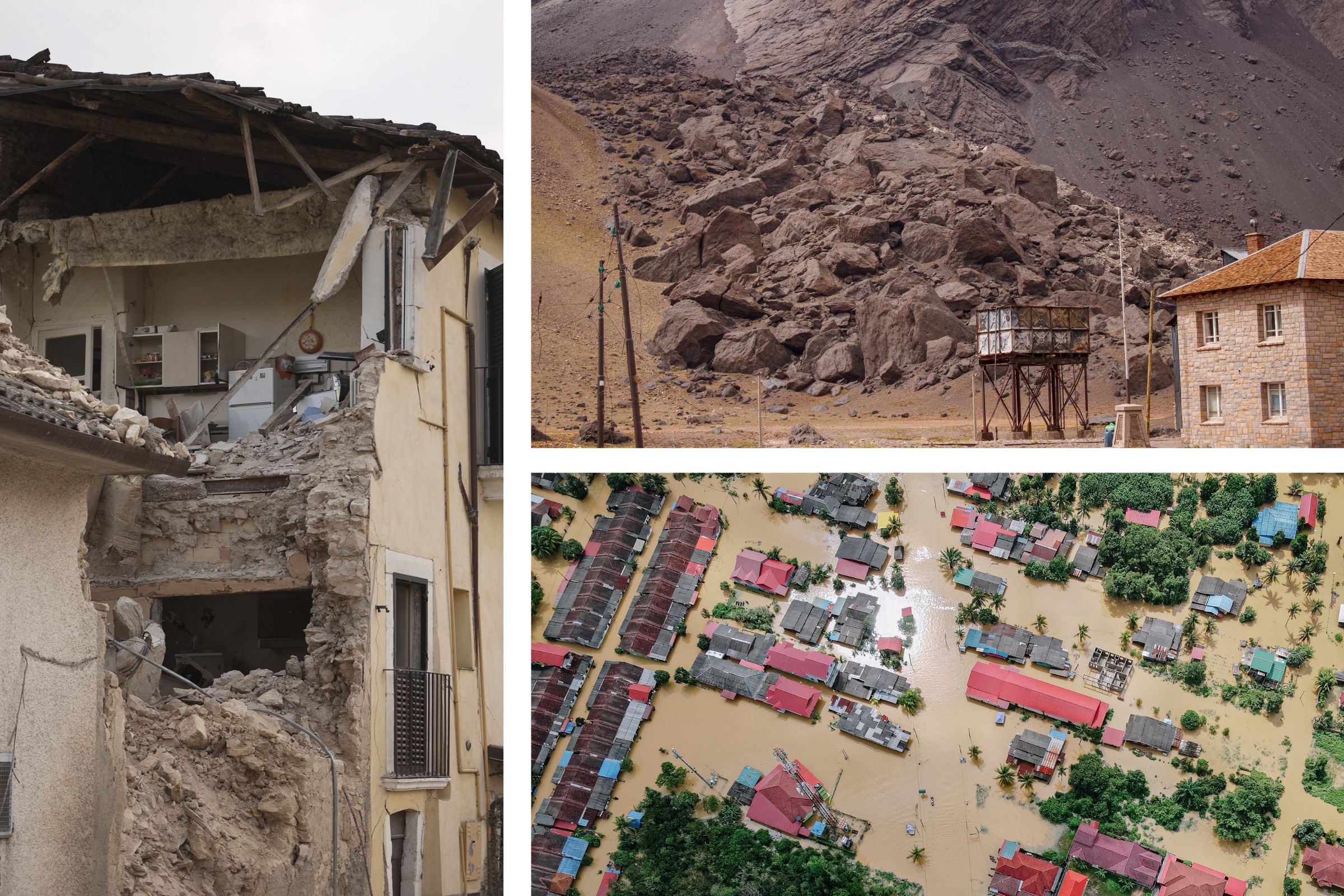
The process starts with identifying the natural hazards that are relevant to a specific location through historical records, stakeholder engagement, field surveys and other sources. Following this, the previously created Urban Scenarios are tested against these hazards using computational modelling. Contrasting to other modelling strategies, Tomorrow’s Cities approach focuses on measuring the effects of a specific hazard scenario rather than assessing the likelihood of hazard events occurring over the long term. This means that, for an earthquake for instance, instead of estimating the likelihood of various levels of seismic shaking at a specific location over a specified period (probabilistic seismic hazard assessment) and then calculate its impact, our researchers analyse the potential impacts of a single, specific earthquake scenario. This approach could focus on assessing either the most severe earthquake that could realistically happen or a series of predetermined earthquake scenarios in a specific region, for instance. A similar approach is used for other hazards such as floods and landslides/debris flow. For the envisioned future urban plan, the simulations calculate the impacts of hazards on the physical infrastructure – buildings, bridges, etc. – revealing the damage caused by hazards of different intensities. This strategy facilitates the interpretation of the impacts by non-technical stakeholders, one of the priorities of Tomorrow’s Cities: democratising risk assessment.
 Hazard and impact modelling process. Computed Impact Metrics are formal summaries that evaluate the effects of a specific natural hazard within a defined spatial and temporal scope.
It is now time to calculate the impact of hazards on the social fabric of the Urban Scenario. Using socioeconomic and demographic projections, as well as considering the interdependencies between individuals and infrastructure within the Urban Scenario our team can assess how hazards will disrupt people’s lives.
Instead of just capturing the damage to a building, we can assess how that damage, a collapsed school or workplace, for instance, will affect a person’s life.
Gemma Cremen, lecturer in Risk and Resilience Engineering at University College London, Co-lead of the Hazard & Impact Modelling Stage.
Combining both – the damage to infrastructure and to the social fabric of the city – a set of Impact Metrics, such as the number of displaced households, the number of children that faced education disruption, number of workers unemployed or even casualties can be calculated. Each of these metrics can be disaggregated. For instance, the number of displaced individuals or unemployed workers can be broken down by age, gender and income, providing valuable information on how hazards affect different social groups such as children, women and, most importantly, the most disadvantaged communities. It also enables visualisation of how different scenarios –corresponding to the diverse pool of stakeholder’s visions and different policy choices – are affected by hazards. As each scenario consists of a different layout of buildings and people, the same hazard will cause different physical and social disruption in each.
Equipped with that information, it is now time to re-engage with the communities to discuss what these results mean to them and readapt the policies to reduce risk.
In the context of Tomorrow’s Cities, risk refers to the collective values of collaboratively selected risk metrics that are weighted in line with the priorities of stakeholders defined in previous stages of the process.
Jeremy Philips, Professor of Volcanology and Natural Hazards, School of Earth Sciences, University of Bristol, Co-lead of the Hazard & Impact Modelling Stage.
The case of Dar Es Salaam, Tanzania
Mianzini, a ward in Temeke Municipality, Dar Es Salaam, houses around 23,000 residents. Situated on hilly terrain, it faces issues like seasonal flooding and landslides due to its lower areas turning into a river during the rainy season. Informal housing dominates the slopes, while inadequate infrastructure like pit latrines and the absence of a storm-water drainage system exacerbate flooding risks.
It was against this background that the Tomorrow’s Cities team gathered in December last year with a diverse group of stakeholders, including elders, youth, valley residents, and local leaders to explore their visions and aspirations for the future. From those engagements and after expert analysis, a set of digital land-use plans were created representing each of the stakeholders’ future visions.
Preliminary modelling results show how different types of impacts (represented by different impact metrics) are minimised in different visioning scenarios. For instance, the Visioning Scenario produced by the “Residents Group” yields the lowest number of displaced households but the that of the “Elderly Group” results in the lowest number of households with no access to healthcare. These results underscore the importance of considering different voices and impact types when assessing risk from natural hazards.
 The flood damage assessment encompasses all asset types, including building infrastructure, the electrical power network, and the road network. In the map, green and red boxes denote buildings, with red indicating flooded buildings. Notably, the two power stations north of the city remain unaffected by the flood.
 Zooming in on the most affected area reveals a closer look at the flood intensity map. It’s evident that buildings nearer to the riverbed are more likely to be flooded. The dashboard enables users to view the attributes of each selected building in the left panel. The impact metrics displayed below are automatically adjusted to the bounding box of the map.
Equipped with these results, our researchers will return to Mianzini to discuss them with stakeholders. In these workshops, the impact modelling results are communicated through an interactive risk dashboard to aid understanding. Participants can evaluate risk distribution and equity implications, leading to discussions on policy changes. Expert guidance ensures informed discussions, with outcomes informing revisions to Urban Scenarios. This iterative process fosters learning and continuous improvement of plans and policies.
Our next article will explore that process.
In the meantime, follow us on Twitter and LinkedIn
Share Article