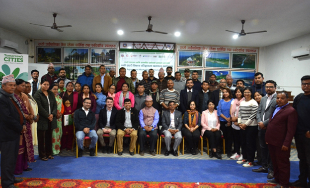
In course of developing disaster resilient new Rapti city, scientific studies based on multi-stakeholder consultations have now come up with possible future scenarios and multi-hazard impacts for the provincial capital city. Under the collaborative effort of Provincial Infrastructure Development Authority (PIDA), Local Governments, Tomorrow’s Cities research project and stakeholders, Risk Agreement Workshop has been held in Rapti during Nov 30-Dec 1, 2023. Tomorrow’s Cities International and National Team including NSET, IOE, Practical Action, NDRI & SIAS showcased the impact results for the previously detailed plans in Future Rapti City. Based on this, the community groups and stakeholders discussed policy modifications on the plans they sowed the seed to formulate, this time, based on the multi-hazard physical and social impacts they learned in this workshop. The attendees appreciated seeing the multi hazard impacts on their future city in full picture and detail. The team guided the 6 disaggregated groups to decide on 3 clear policy suggestions that would realistically reduce physical and social impact in Tomorrow's Rapti.
The 2-day Risk Agreement Workshop was organized in Rapti, the Lumbini Provincial Capital City with a view to bringing city stakeholders together to collectively assess the risk modelling results, including Impact Metrics for the future Rapti city.
The Workshop was kicked off with a brief opening session, where brief remarks and program highlights done by CEO Mr. Chhabi Raj Pokhrel from The Provincial Infrastructure Development Authority (PIDA), Mayor Chhabi Lal Paudel from Shitaganga Municipality, Mr. Yam Narayan Sharma Pokhrel, Chairperson of Gadhawa Rural Municipality, Dr. Ramesh Guragain, Deputy Executive Director from NSET and Mr. Roberto Gentile, Co-Lead for Risk Agreement Module of Tomorrow’s Cities. The guests jointly opened the proceedings by signing on the event banner.
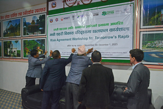
Guests signing on Event Banner to commence proceedings of Risk Agreement Workshop in Rapti, Photo: NSET
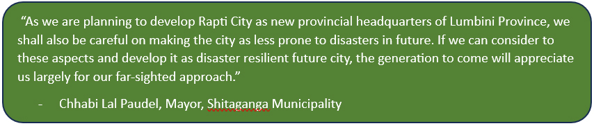
“After an elongated effort, we are in the implementation phase of developing Rapti, which is also provincial headquarters of Lumbini Province, a new city. We are extremely sensible that the newly developed Rapti city should not be prone to any disasters. I would like to appreciate the team of Tomorrow’s City for your utmost efforts, and we are ready to incorporate the findings and suggestions of your study and implement it accordingly”, remarked, Mr. Chhabi Raj Pokhrel, Chief Executive Officer (CEO) from The Provincial Infrastructure Development Authority (PIDA) addressing the participants.
The PIDA has collaborated with Tomorrow's Cities, to ensure the future Rapti City, the Lumbini Provincial Capital City (LPCC) is built resilient to disasters. The local governments from Rapti & Gadhawa Rural Municipalities and Shitaganga Munipality are the key stakeholders of the collaboration. Shaping Visioning Scenarios for future cities is one of the key milestones of the TCDSE.
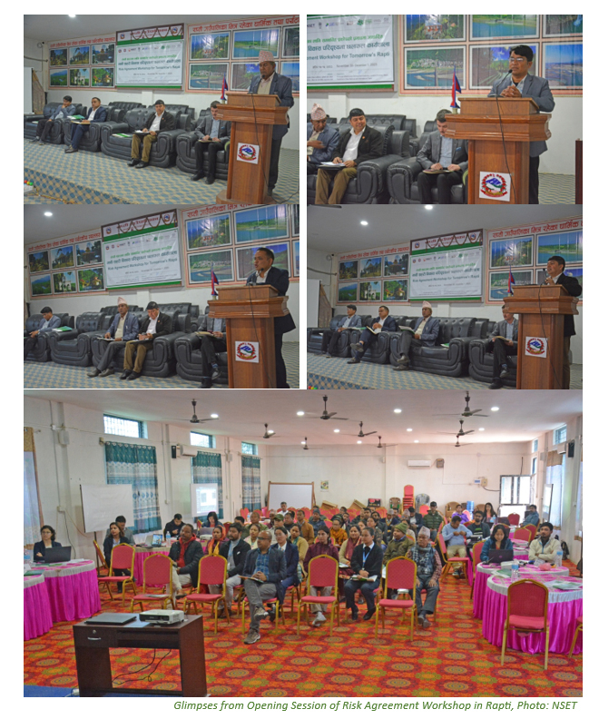
Glimpses from Opening Session of Risk Agreement Workshop in Rapti, Photo: NSET
The formal session of the workshop started with a recap of previous WP activities. The session lead of Work Package 1, 2 and 3 made recap of the activities conducted in each work package. Dr. Dilli Paudel presented the activities done under WP1, Ms. Aditi Dhakal shared the activities in general done under WP2 while Mr. Vibek Manandhar highlighted the activities in general carried out under the WP3.
The review session was followed by a presentation “Introduction to WP4 Risk Agreement” by Roberto Gentile and Dr. Ramesh Guragain. On the occasion, the presenters introduced the concept of the workshop and clarified the objectives and intended outcome of the workshop.
Various representative groups from local communities and authorities and city planners engaged in interactive discussions to review the results of the Computational Risk Model, assess how the Visioning Scenarios will be impacted by hazards, identified changes in the Visioning Scenarios that lead to lower hazard impact and weighed social issues that might undermine the implementation of those changes on Tomorrow’s Rapti city.
Dashboard Exercise: The exercises on the dashboard was done once the participants were introduced to the key terminologies of disaster (Hazard, Exposure, Vulnerability) and were able to make them understand and recognize the disaster words. After that, the dashboard was shown on the laptop and informed about the dashboard, such as: how the dashboard looks like when the dashboard is opened and shown. Participants were informed about the interface visible on the dashboard and practice on the dashboard was done.
In the group exercise, various exercises were done by demonstrating how to use the dashboard properly, such as: Identify the areas with high hazard intensity (Earthquake, Flood), Identify most common building occupancy in high intensity areas, Identify most common material used in high intensity zones , Identify most common income type in high intensity zones, Identify buildings with highest damage state , Identify material used in heavily damaged buildings etc., We practiced the dashboard to the participants.
From the exercise of the dashboard, the participants received information on how to use the dashboard and gained knowledge about how much impact a disaster will have on which area based on the color, for example: in the case of an earthquake, dark blue color will have less impact and darker gray color will have more impact.
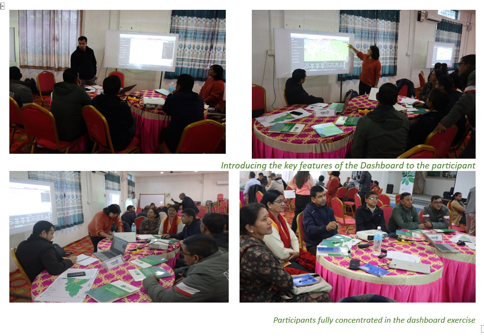
Participants fully concentrated in the dashboard exercise
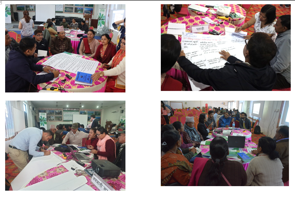
Risk Reveal: In Pahade (Migrant) group, after brief acquaintance with the dashboard, the subsequent task involved unveiling the associated risks. Here, the prime focus was on identifying and discussing the highly susceptible and low susceptible polygons for both earthquake and flood hazards (polygons were explored in advance by the facilitators). Subsequently, the underlying causes behind the high and low impacts were explored so as their mitigative measures to alleviate the impacts in the form of policies.
For Flood (70 years Return Period) (High Impact Polygon)
- Polygon: 95
- Population: 1926
- Building Typologies: Predominantly BCr
For Flood (70 years Return Period) (Relatively Low Impact Polygon)
- Polygon: 380
- Population: 6920
- Building Typologies: Predominantly Rci
For Earthquake (8.2 Magnitude) (High Impact Polygon)
- Polygon: 402
- Population: 1123
- Building Typology: Predominantly BrM
For Earthquake (8.2 Magnitude) (Relatively Low Impact Polygon)
- Polygon: 120
- Population: 1205
- Building Typology: Predominantly Rci
Hazard Mapping: In Pahade (Migrant) group, the hazard mapping mainly focused on flood/inundation and landslide hazard as listed below:
The flood/inundation areas listed out are as follows:
- Flood inundation caused by Aap kholi and Feuri river in Bhalubang area, RRM-1
- Inundation caused by river between Bhalubang and Pulchowk in RRM-1
- Khukhure river in the Dursanchaar area in Pakhapani, RRM-1 that caused more damage to the settlements compared to the Rapti river
- Inundation in Lalmatiya, RRM-2 on the way to Ramnagar; Drainage problem due to the construction defect (rather than lining them in straight line, they put the drainage pipes zigzag leading to the obstruction in passing the water and flooding the surrounding.
- Inundation in Maurighat, Naya Gaun, RRM-4
- Inundation in Sisahaniya and the adjacent areas in the western part by Dolai and Singhe River mixed with seasonal rivers like Bhaiswaar River among others originating from the Northern Chure
Similarly, landslide prone areas were also mapped and listed as below:
- The entire Sitganga area being the hilly region are somehow prone to landslides especially SM9
- The Bagasoti area in RRM-1, and Chaite are highly prone to landslide
- Devikot area of RRM 9 and Bhulke or RRM 5 are equally susceptible
After navigating through the dashboard and verifying the flood and landslide prone areas in their proposed land use map of capital city; the participants were briefly asked the types of building typology that existed in the past in the capital city and the future trend.
- Mud Houses with thatched roofs by personal interest in the past and at present times as well
- Policy has been introduced for constructing buildings strictly following building process permits and building codes by the local authority; though some ignored the policy and constructed without following the building codes
- Awareness among the population is getting better; only those with poor economic status build the houses without following building codes
- Sparing already built houses, the newly constructed houses are according to the building codes
Ideas to reduce earthquake impact:
- Implementation of building codes for earthquake-resilient building construction
- Fines/Penalties against those who neglect the building code provisions or opt out of utilizing the services and facilities offered at the ward level, such as recommendations for drinking water pipelines, electricity, etc among others
- Subsidize people of low-income groups for tasks related to building code implementation
- Increase the accountability of government officials involved in building code implementation
- Establish mechanisms for disaster recovery and rescue operations
- Preservation of public lands and open areas
- Retrofit of existing structures like schools and community buildings where financially feasible
- Provide training and raise awareness among professionals involved in building codes implementation
- Regular monitoring of Buildings during construction to prevent any discretion from building code to prevent wastage of time and money later
- Restrict the use of residential buildings which are structurally deficient, promote retrofitting or reconstruction as feasible
Ideas to reduce flood impacts:
- Embankments on the seasonal rivers based on scientific analysis (according to the flow and the shape of the rivers)
- Management of the risk-prone settlements/building near river banks
- Roadside drainage well-connected to local rivers
- Preserve the natural flow of the river and prevent encroachment of the river banks and the buffer zones
- Establish an early-warning system for flooding
- Raise possible awareness on why it is important to avoid /minimize the construction in high flood hazard risk zone
- Use bio-engineering/bio-fencing methods in the construction of embankments around small or seasonal rivers. This involves selection and plantation of trees and plants of appropriate types like Bamboos, Sissoo (Dalbergia Sissoo), Bainse (Salix tetresperma), Chiuri or Butter Tree (Diploknema Butyracea), Narkat (Arundo clonax) etc
- Prevent haphazard extraction of river resources
- Preservation of lakes and ponds
- Only allow low-density settlements in high-risk prone areas
Pahade (Migrant) group had 3 policy modifications while other group also had similar brainstorms.
- Restrict the use of residential buildings which are structurally deficient, promote retrofitting or reconstruction as feasible
- Use bio-engineering/bio-fencing methods in the construction of embankments around small or seasonal rivers. This involves selection and plantation of trees and plants of appropriate types like Bamboos, Sissoo (Dalbergia sissoo), Bainse (Salix tetresperma), Chiuri or Butter Tree (Diploknema Butyracea), Narkat (Arundo clonax) etc.
- Implementation of building codes for earthquake-resilient building construction
Once the top 3 policies were prioritized, participants engaged in discussions regarding the implementation challenges associated with each policy. Policy cards containing the challenges identified during the validation workshop were distributed for review. Following a brainstorming session, participants collectively identified potential challenges. Later on, the participants were prompted to propose potential solutions aimed at addressing these challenges.
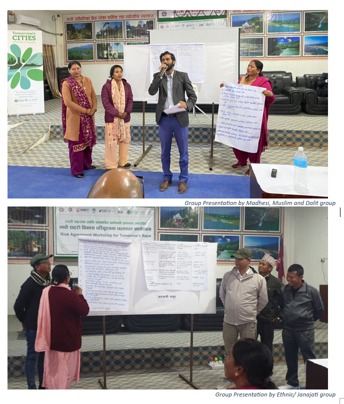
Group Presentations: The Madhesi, Muslim and Dalit group went quite well and was successful to meet its objectives. All 3 exercises were conducted effectively, and all participants fully participated, discussed, learned about the risk of the potential hazards in the city. They learned about the disaster parameters such as hazards, exposure, vulnerably, risk, impact and their interlinkages. Dashboard made them visualize and understand those parameters in a simple and effective way. They were also able to discuss the reasons of impact and could also present the solutions to reduce the impact. This workshop sensitized the community people to understand the DRR and to work on it for Rapti city.
The workshop was formally concluded with a brief closing session. The session was graced by Mr. Baldeep Sharma, Officer from National Disaster Risk Reduction and Management Authority (NDRRMA), Dr. Ramesh Guragain and Mr. Roberto Gentile from Tomorrow’s Cities.
Reporting by Mahanand Timalsina and Khadga Sen Oli (with the support from Risk Agreement Workshop Facilitation Team) for Tomorrow’s Cities Communication. For any query, please write to ksenoli@nset.org.np or rapti@tomorrowscities.net