Summary
Jalia Palong Union Parishad, Cox’s Bazar, Bangladesh
Jalia Palong is a very promising and beautiful union located in the southwestern part of Cox's Bazar Sadar Upazila of the tourist city of Cox's Bazar in Bangladesh. The distance of this union from the Ukhia Upazila headquarters is about 10 kilometers. Cox's Bazar Municipality and Jhelongja Union to the north of this union; Patali Teknaf Upazila to the south; Rajapalong Union to the east. Jalia Palong is a union located in Cox's Bazar, Bangladesh's Ukhia Upazila. The food security, economic vulnerability, market access, employment possibilities, and environment of the Bangladeshi host villages have apparently been significantly impacted by the sudden and large growth in the refugee population, which is centered in the south of the district in Ukhia and Teknaf. Informal settlements, urban growth, and other issues are common in the region. The creation of sustainable housing, services, and infrastructure that satisfies community requirements can be facilitated by Tomorrow's Cities. The Jalia Palong union in Bangladesh's Cox's Bazar is dealing with a number of environmental issues like cyclone, landslide and flood.
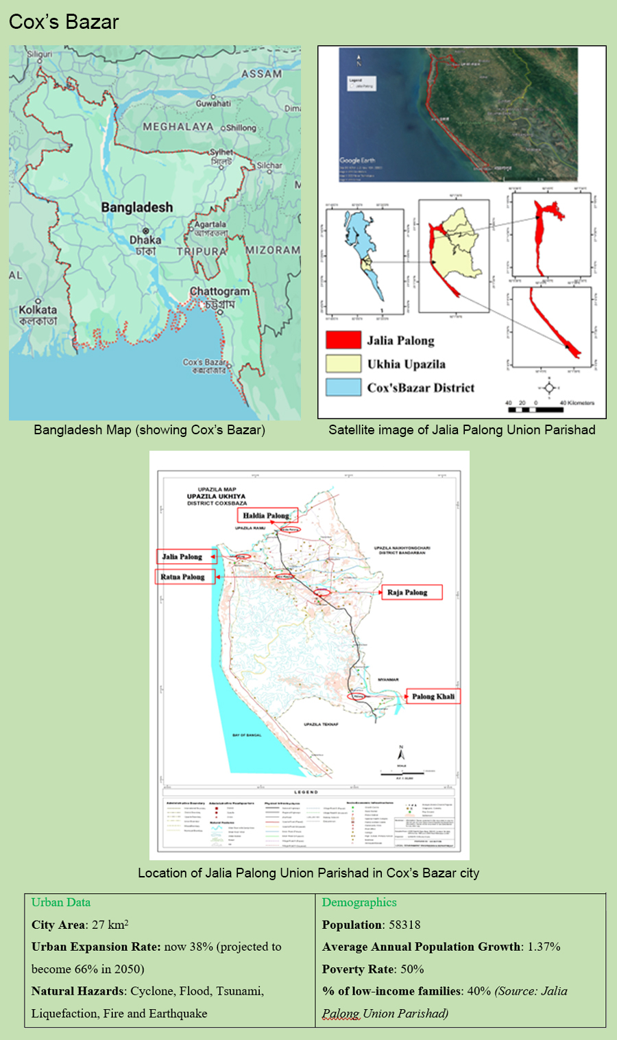
Jalia Palong has a total land area of 27 km2 having population of 58318. The annual growth rate us 1.37%. There are 58 mosques, and 2 temples. It has 50 villages and 8511 families in this union. Moreover, 2 growth centres exist here. The local government comprises of 9 ward which has 12 wards members including 3 female and one union parishad chairman. Jalia Palong has 17 primary schools, 2 high schools, 8 madrasa, and 1 Upazila Health Center. The literacy rate is 27.16%. Its road network consists of 17 paved roads and 74 mud roads, and 29 bridges or culverts. Moreover, there exists 1 canal/river.
Urban Context and Development Trend
The level of urbanization in Bangladesh is now 38% which is projected to become 66% in 2050. The population growth rate in Jalia Palong is 1.37%. A 20-year-long master plan to transform the tourism city Cox’s Bazar into a modern and smart city is likely to be initiated next month.
Multi-hazard context
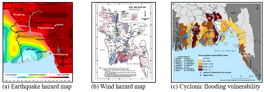
The coastal zone of Bangladesh has been recognized as one of the top fifteen risk hotspots around the globe, being exposed to multiple environmental hazards including cyclone, storm surges, sea-level rise, flooding, shoreline erosion, land degradation, salinity ingression, and subsidence including earthquake. Cox’s Bazar is located in the coastal zoom which is subjected to medium to a major level of natural disaster. The unprecedented urban infrastructure planning and industrialization within the next few years are assumed to change the current scenario of Cox’s Bazar city. A proper prediction of the multi-hazard risk due to the modern urbanization and industrialization of these cities is important for safe living. Therefore, with the help of the TCDSE framework, the local research time is intended to assess the risk of multi-hazards of Chattogram and Cox’s Bazar cities.
Jalia Palong is a disaster-prone area subjected to cyclone, flood, Tsunami, liquefaction, Fire and earthquake. This year monsoon flood caused five people dead and Nearly 300,000 people across 60 union parishads in Cox’s Bazar have been impacted. This zoon is classified as a deadliest zoon in Bangladesh National Building Code-2020 due to earthquake. Due to sandy geological strata, this area is also highly susceptible to liquefaction. A comprehensive study done by Comprehensive Disaster Management Program (CDMP) claimed that this is highly vulnerable for Cyclone, Storm surge and Tsunami.
Past DRR Works
The local research team is comprising social scientist, GIS expert, natural hazards modelling. Some of the past DRR work done the research teams is mentioned below.
- CDMP I (2009) which was a Comprehensive Disaster Management Programme on Chattogram city. It focused on the Seismic Hazard Assessment [and Secondary Hazards (e.g., Liquefaction)], Seismic Vulnerability Assessment of Buildings, Scenario Seismic Risk Assessment of Buildings, Infrastructure Systems, and Essential Facilities using HAZUS.
- Tsunami & Cyclone Vulnerabilities of Cyclone Centres, Schools, Colleges, etc., Hospitals, Emergency Facilities and estimation of social loss in Chattogram and Cox’s Bazar cities.
- Earthquake Vulnerability Assessment of Existing Buildings in Cox’s-Bazar using Field Survey & GIS
- Tropical cyclone risk mapping for a coastal city using geospatial techniques.
- Seismic Safety Assessment of Government Primary School Buildings in Chittagong City Corporation.
Present DRR Agenda
To achieve the SDG goals, the Government of Bangladesh and the Ministry of Disaster Management and Relief establish plannings, rules regulations and different agendas on disaster risk reduction throughout the country. Among these Disaster Management Act 2012, Disaster Management policy 2015, Bangladesh National Building Code-2020, 100-year Bangladesh Delta Plan-2100, National Disaster Management Plan for the period 2021-2025 and SENDAI Framework for Disaster Risk Reduction are remarkable. The primary goal of these agenda is “Action for Disaster Risk Management Towards Resilient Nation”. The NPDM 2021-2025 targets aligned with SFDRR its four priorities and Asian Regional Plan for Disaster Risk Reduction (ARPDRR) with the vision of “Winning resilience together against all disasters”
The extensive stakeholder and expert consultations undertaken to develop NPDM 2021-2025 focused on the following SFDRR priorities and action plans were derived following an ‘all-hazards’ approach with hazard-specific activities linked to broader priority level action plans.
Priority 1: Understanding disaster risk.
Priority 2: Strengthening disaster risk governance to manage disaster risk.
Priority 3: Investing in disaster risk reduction for resilience.
Priority 4: Enhancing disaster preparedness for effective response and to “Build Back Better” in recovery, rehabilitation, and reconstruction.
Future Development Project or Initiatives
The GoV of Bangladesh is planned 77 projects in Cox’s Bazar with the vision of 2041 in order to develop the coastal slope by the Bay of Bengal like a Singapore or Hong Kong city. Sabrang Exclusive Tourist Zone of Teknaf on 1139 acres. Some of future project nearest to the proposed area are Jaliyardip Exclusive Tourist Zone of Teknaf on 271 acres of land, Ramu Pechardip National Oceanic Research Institute on land 29.5 acres at cost of Tk. 8075 lakh, Jalia Palong shelter project on 253.35 acres having a Sheikh Hasina tower and 149 multi-storeyed buildings, Cox's Bazar International Airport Project at a cost of Tk 1123.32 crore, Dohazari-Ramu to Cox's Bazar to Ghumudhum Railroad at a cost of Tk 18, 034 crore, Matarbari Coal Electric Project on 1,414 acres of land at Maheshkhali at a cost of Tk 35, 984 crore, LNG Terminal at Maheshkhal including 90 km pipeline, Sonadia deep sea port, Construction of submarine base of the Navy in Pekua on 333 acres land, and Chattogram to Cox’s Bazar Express Way of total Budget, Core 2000 BDT. This project will increase working opportunity, infrastructure development and the economic development which is expected to increase the urbanization very rapidly in the proposed area.
Challenges
Jalia Palong faces hazards primarily due to its geographical location along the Bay of Bengal, making it susceptible to cyclones, storm surges, and flooding. The region's hilly terrain also contributes to the risk of landslides, particularly during heavy rainfall. Additionally, factors such as environmental degradation and inadequate infrastructure further amplify the challenges posed by natural disasters in Jalia Palong.
Cyclones and Storm Surges: Cox's Bazar is prone to cyclones and storm surges due to its location along the Bay of Bengal. These natural disasters can cause widespread damage to infrastructure, displacement of communities, and loss of life.
Flooding: Low-lying areas in Cox's Bazar are susceptible to flooding, especially during the monsoon season. Heavy rainfall and poor drainage systems can contribute to flash floods and river overflow.
Landslides: Hilly terrains in and around Cox's Bazar are susceptible to landslides, particularly during heavy rains. Deforestation and improper land use can exacerbate this risk.
How can Tomorrow’s Cities help or bring to Cox’s Bazar?
In this project the risk and vulnerability maps along with the hazard maps will be prepared and consulted with the local people. The vulnerable group of people must be included in the plan preparation and finalization phase to increase the sustainability of the plan. One challenge can be the inclusion of such group in plan preparation phase but the local government development authorities can help in organizing such meetings.
The outputs and outcomes of the engagement with tomorrow’s cities is followings:
- Capacity development on decision making risk reduction on future cities planning both in public and private sector.
- Capacity development on different hazards and its impact assessment through training and workshop.
- Empowerment of the citizens, stakeholders and beneficiaries in the decision making.
- Hazardless mapping of considered area those could be implemented in the Master Plan preparation.
- International collaboration and future research work on similar works on other cities of Bangladesh and other underdeveloped countries.
- Multi-hazard vulnerability and risk assessment of the considered area.
The following groups are responsible for continuing the work of Tomorrow’s Cities after the International teams leave the city.
- The CDA team
- The CoxDA team
- The CUET team
- The DU team
Main stakeholders
- Cox’s Bazar City Development Authority
- Cox’s Bazar Paurashava
- Chittagong University of Engineering & Technology
- University of Dhaka
