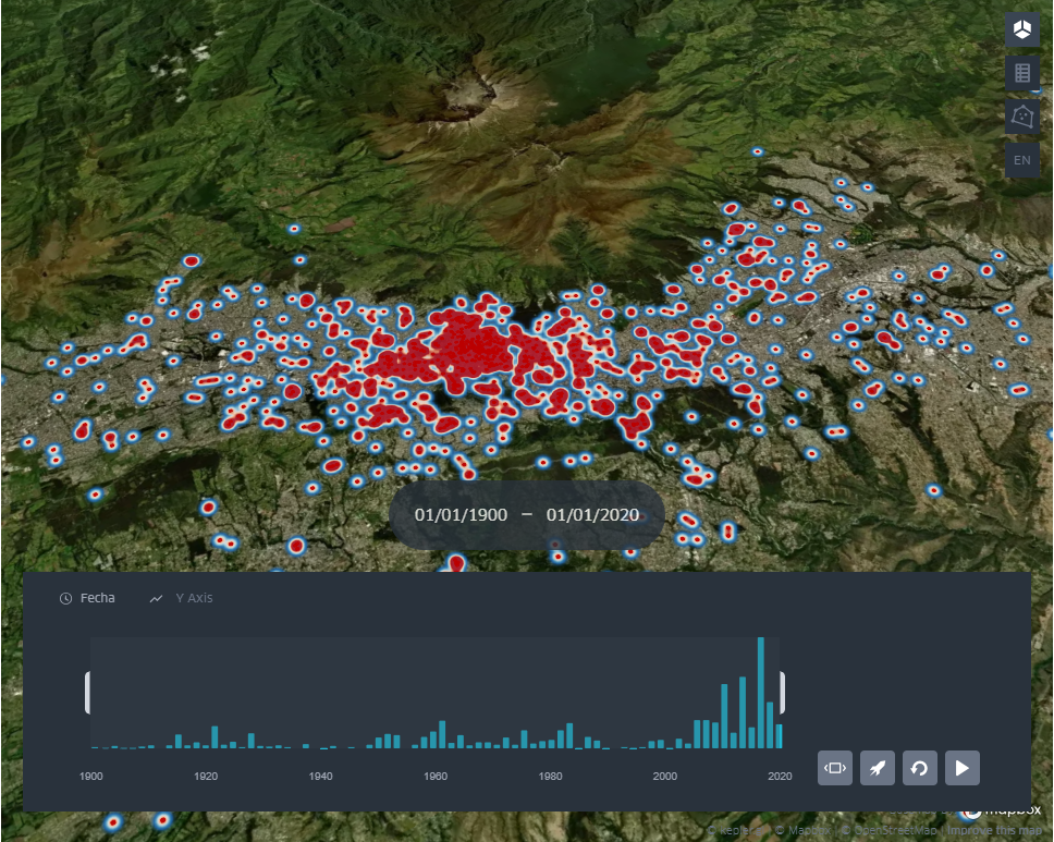
Map showing the presence of "hotspots" for landslides, floods, and mudslides occurrences in Quito.
As part of research conducted during the course of Quito's participation in Tomorrow's Cities, an interactive data visualisation tool was just launched online.Using data spanning 120 years, between 1900 and 2020, this risk communication tool shows occurrences of landslides, floods, and mudslides, revealing hotspots of events and how these have shifted along the years.
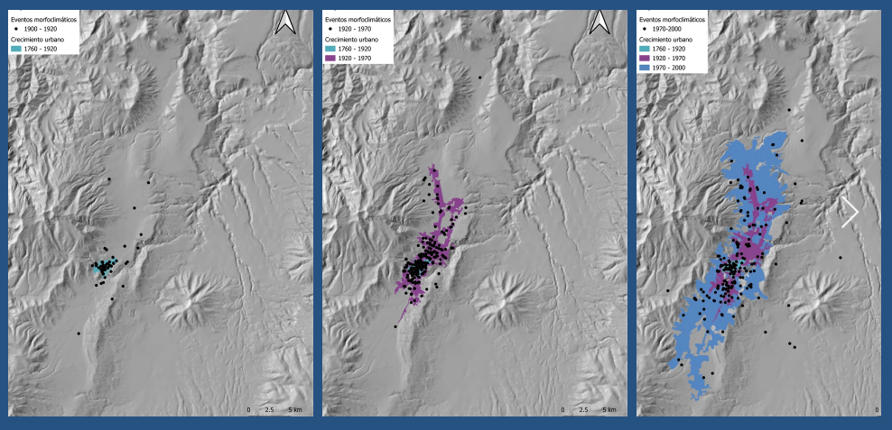
Quito expansion between 1900 and 2020 with landslides, mudslides and floods marked.
Based on a meticulous analysis of press reports from leading newspapers in the region, the work started in 1989 by the renowned French geographer Pierre Peltre and continued with Tomorrow's Cities researchers and the University of San Francisco de Quito Data Hub, a research laboratory specializing in the collection, analysis, and visualization of vast datasets.
The research meticulously traces the movement of "hotspots" for these environmental hazards over time, illustrating how they have shifted in response to the changing urban landscape. At the turn of the 20th century, these events were concentrated in the Historic Centre of Quito. However, as the city expanded, so too did the reach of these hazards, encroaching upon new areas in alignment with urban development.One striking revelation is the correlation between the city's expansion and the incidence of morphoclimatic events, particularly during the 1970s boom fueled by the oil industry. As Quito experienced rapid urbanization and population growth, it became increasingly susceptible to phenomena such as landslides, floods, and mudslides.
Perched between the steep slopes of the Pichincha volcano to the west and those of an active geological fault system to the east, Quito is highly prone to multiple hazards such as earthquakes, volcanic eruptions, floods and landslides. The city is also rapidly expanding, and in 2018 became Ecuador’s largest city.
In recent years,the La Gasca landslide of 2022, caused 28 fatalities and around 2 million dollars in intervention expenses in the affected area.
"Behind each event, there is not only a story of tragedy but also valuable scientific information that can be rescued through a database. Historical study allows for a better understanding of these phenomena in the unique context of the city and is a key tool for disaster risk management and the construction of a resilient society."
Elisa Sevilla, Quito Risk Hub Manager.
Professor Sevilla's research interests are in the history of disaster risk, with a specific focus on understanding the root causes of urban risk in Quito from a perspective of the history of emotions and history of knowledge circulation.