Photo by Çağlar Oskay on Unsplash
In 2002, a research paper published in the Earth and Planetary Sciences Letters highlighted the stress accumulation on the East Anatolian Fault, forecasting that the Kahramanmaras – Malatya region was the most likely location for a very large earthquake. The incident of February 6th proved in the most tragic way that the researchers’ forecast was correct.
Nature magazine just featured this study and we interviewed Professor John McCloskey, one of its authors, who highlighted the need for global action to reduce risk in areas of remarkable hazard.
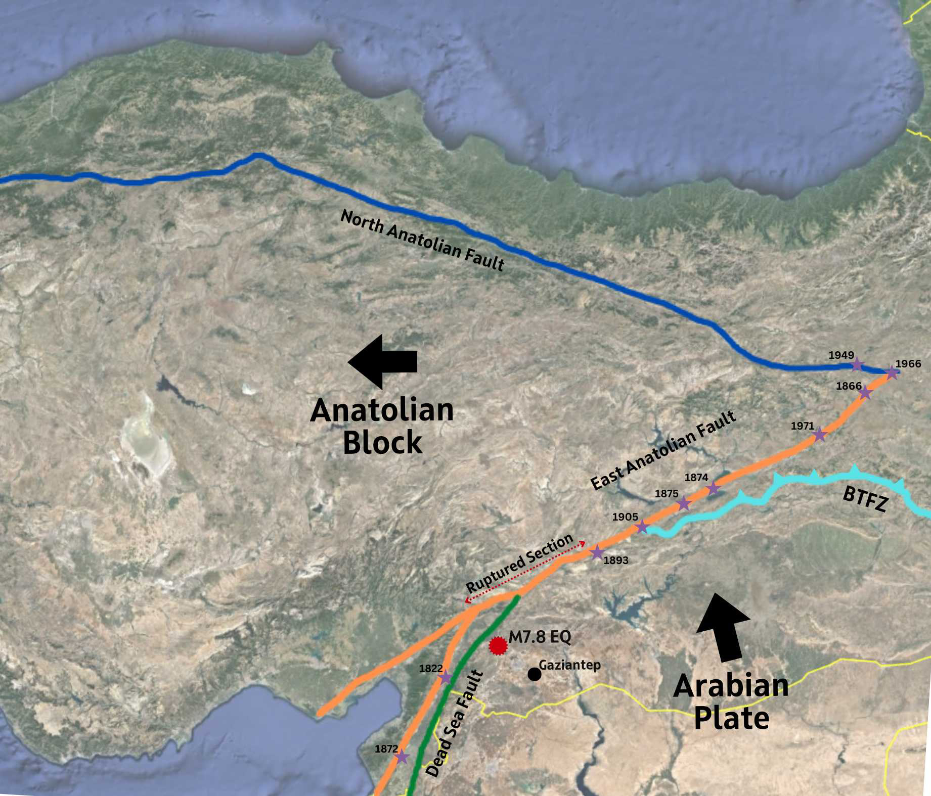
Map showing the eastern Anatolia tectonic setting and the location of historical earthquakes (purple stars) used in the study for modelling. The red marker shows the location of the M7.8 Kahramanmaras Earthquake that shook the region on February 6th. Bold arrows indicate the relative movements of the plates. BTFZ: Bitlis Thrust and Fold Zone.
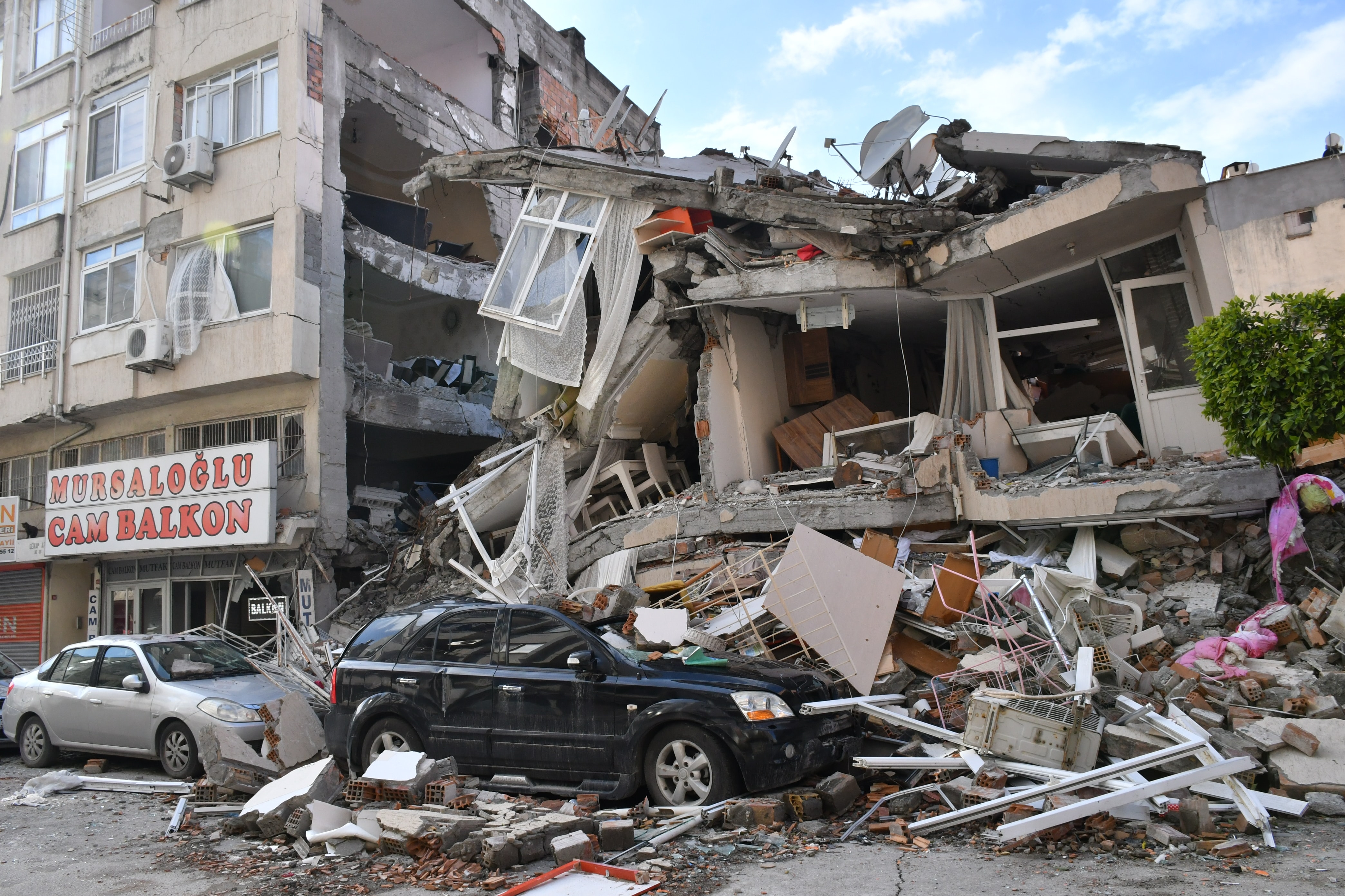
At 4:17 am local time on February 6th a M7.8 earthquake struck south of the city of Kahramanmaras, in southern Turkey. 9 hours later, a second M7.5 event, the largest aftershock, occurred near Elbistan, 95 kilometres northeast of the first earthquake. Over the next two weeks in all 6 earthquakes of magnitude greater than 6 have rocked southern Turkey and northern Syria.
This earthquake sequence was a tragedy, but not a surprise.
In a paper published in 2002, researchers from Turkey and Ireland, analysed the stress due to tectonic movement along the east Anatolian fault - which geologically separates Turkey to the north west, from Syria to the south east - and a series of great historical earthquakes along this plate boundary. At the time, they concluded that two sections of the fault were highly stressed and likely to generate large earthquakes in the near future.
The first of these sections – Elazig- Bingol (EB)- partially ruptured in 2010 in the M6.1 Elazig earthquake which killed between 40 and 50 people.
The second, and main focus of the 2002 paper, was the Kahramanmaras – Malatya (KM) Region where the modelling showed that stress accumulation might generate a >M7.3 earthquake.
It was precisely this region that on February 6th, stress loaded by a small earthquake to the south of Kaharamanmaras caused rupture. Not only did the KM section break but the earthquake ripped through the ends of the fault segment highlighted in 2002, to the NE into an area which last ruptured in 1893 and to the SW through the area last broken in 1822. More than 400km of the plate boundary were ruptured, generating a M7.8 earthquake. The largest aftershock, the M7.5 Elbiston earthquake, occurred about 9 hours later.
In a recent news feature, Nature magazine brought back this remarkable and tragic finding, highlighting the current ability of earthquake science to identify the most hazardous regions and help policy makers designing risk-informed urban plans.
We talked with Professor John McCloskey, one of the authors of the study and Principal Investigator/Co-Director of Tomorrow’s Cities.
TC: What does this, almost perfect match, between the 2002 study and last February’s event tells us?
JM: The work we reported in 2002 was a great success of the method and identified precisely the part of the East Anatolian Fault which initiated this recent rupture and released most of the energy. However, the Kahramanmaraş earthquake also demonstrated the problems with making precise forecasts. Because they had previously been ruptured, most earthquake scientists would have expected that the 1822 and 1893 segments would still have been too relaxed to release much energy, but they still slipped by as much as 5m releasing a lot more energy and causing more devastation.
TC: Does this mean we can now accurately forecast earthquakes?
JM: The incident of February 6th, proved in the most tragic way not only the accuracy of the 2002 forecast but also the urgent need of global action to reduce risk in areas of remarkable hazard. The good news is that, since its publication, the physics of earthquake interaction has evolved and is now sufficiently advanced to allow the identification of individual faults where high stress levels indicate particularly high risk. Maps of the rate at which the earth’s crust is deforming measured by satellite radar also allow us to identify whole regions that will certainly experience large earthquakes in future.

Forecast published in the 2002 article (left) and the USGS observations on surface fault rupture of the February 6th Kahramanmaraş Earthquake Sequence (right). On the USGS image, red colours indicate movement to the east, so the earthquake rupture is marked by colour contrast across the fault. The main rupture extended both to the south, last ruptured in 1822, and to the north which last ruptured in 1893. Similar pattern to the north marks the surface displacement of the M7.5 Elbistan aftershock.
TC: Are we close to being able to predict specific earthquakes then?
JM: No. Predicting individual earthquakes is, and will probably remain, impossible. However, with the current state-of-the art there will be few surprises about where the destructive earthquakes will occur. SE Turkey is and will remain a seismic danger zone.
TC: If prediction isn't possible what can authorities in high-risk areas do to protect their citizens?
JM: causes of disaster are systemic not singular, so getting the science right is only a part of the problem. Reducing risk is more than just forecasting hazard, it costs money and requires commitment. Unfortunately, and too often, those in authority are willing to gamble that the big one will not happen on their watch. Still the scientific story behind the devastation experienced in the last month in Turkey should not focus on blame. This only directs attention away from the problem. Instead, it should motivate worldwide change in our approach to development in areas of high seismic risk.

Surface rupture in Hassa Town. Photo: OzdemirAlpay
TC: But with urban population expected to increase dramatically in the next 30 years, doesn’t that mean more people will be at risk?
JM: In fact, UN’s Habitat predictions that between now and 2050, about 2 billion people will flood into urban centres across the globe, with 95% of them in the global south. This unstoppable movement prompted the formation of the Tomorrow’s Cities Hub, a multidisciplinary research project working internationally to reduce disaster risk in future urban developments, with special emphasis on the poor and most marginalised. Although the time is limited, I and the 100 or so researchers working in the Hub, many of which are Turkish, believe this provides an historically unique opportunity to protect future urban dwellers from avoidable disaster risk caused by earthquakes, flood landslides and other hazards.
Reducing risk increases the cost of development and requires joined up thinking to untangle the scientific, economic and political causal chains and bring about systemic change. Multi-sectoral coalitions empowered by, sometimes sceptical, authorities are essential if we are to transform the socio-political environments that turn earthquakes into disasters. This is not just a scientific or engineering problem!
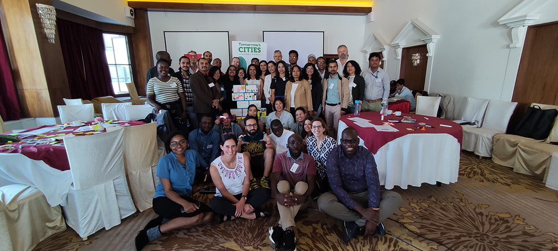
Rsearchers from the Tomorrow's Cities Hub meeting in Kathmandu in 2022.
The Kaharamanmaras Earthquake, for which satellite data suggests that poor areas suffered 3.5 times more damage than richer regions, shows the pertinence of project’s such as Tomorrow’s Cities. With that belief in mind, Professor McCloskey reflects about the future of the Turkish and Syrian cities affected by the earthquake:
‘If such joined-up thinking emerges during the reconstruction after the Kahramanmaras earthquake, and in the next 30 years of global urbanization, then something positive might yet emerge from this tragedy.’
Professor John McCloskey, Principal Investigator and Co-Director of the Tomorrow's Cities Hub